


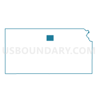
Logan Township Voting District, Mitchell County, Kansas
About
Outline

Summary
| Unique Area Identifier | 585961 |
| Name | Logan Township Voting District |
| County | Mitchell County |
| State | Kansas |
| Area (square miles) | 35.95 |
| Land Area (square miles) | 35.91 |
| Water Area (square miles) | 0.04 |
| % of Land Area | 99.89 |
| % of Water Area | 0.11 |
| Latitude of the Internal Point | 39.34791570 |
| Longtitude of the Internal Point | -97.98193010 |
Maps

Graphs
Select a template below for downloading or customizing gragh for Logan Township Voting District, Mitchell County, Kansas


Neighbors
Neighoring Voting District (by Name) Neighboring Voting District on the Map
- Asherville Township Voting District, Mitchell County, KS
- Beloit Township Voting District, Mitchell County, KS
- Bloomfield Township Voting District, Mitchell County, KS
- Eureka Township Voting District, Mitchell County, KS
- Salt Creek Township Voting District, Mitchell County, KS
- Simpson City Voting District, Mitchell County, KS
- Solomon Township Voting District, Cloud County, KS
Top 10 Neighboring County Subdivision (by Population) Neighboring County Subdivision on the Map
- Solomon township, Cloud County, KS (591)
- Beloit township, Mitchell County, KS (205)
- Logan township, Mitchell County, KS (125)
- Asherville township, Mitchell County, KS (97)
- Bloomfield township, Mitchell County, KS (76)
- Salt Creek township, Mitchell County, KS (33)
- Eureka township, Mitchell County, KS (22)
Top 10 Neighboring Place (by Population) Neighboring Place on the Map
Top 10 Neighboring Unified School District (by Population) Neighboring Unified School District on the Map
- Beloit Unified School District 273, KS (5,061)
- Southern Cloud Unified School District 334, KS (1,488)